 The dam at Westville Lake is situated on the Quinebaug River in the towns of Southbridge and Sturbridge, about 18 miles southwest of Worcester and 25 miles east of Springfield. From Sturbridge, the dam is two miles south on Route 131, right on West Street, right on South Street, right on Marjorie Road. This facility is part of a network of six dams constructed and maintained by the U.S. Army Corps of Engineers to relieve the effects of flooding along the major rivers of the Thames River Basin.
In conjunction with the dam at East Brimfield Lake, the dam at Westville Lake substantially reduces flood damages in Southbridge and Dudley, Mass., and Putnam, Danielson, Jewett City, and Norwich, Conn. These communities are predominantly industrial with business centers on the Quinebaug River.
Construction of Westville Lake started in April 1960 and was completed in August 1962 at a cost of $5.7 million. The project required the partial relocation of Route 15 (now U.S. Route 84); U.S. Route 20; Route 131; South Street in Southbridge and Mashapaug Road in Sturbridge; and various pipelines, water supply facilities, and electric and telephone utility lines. The project has prevented $53.7 million in flood damages since it was built (as of September 2011).
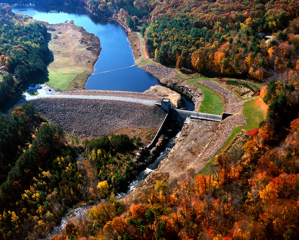
The project consists of an earthfill dam 560-feet long and 78-feet high; three gated rectangular conduits, each measuring six-feet high, four-feet wide, and 63-feet long; and a chute spillway founded on bedrock with a 200-foot-long weir. The weir’s crest elevation is 15 feet lower than the top of the dam.
Westville Lake contains a 23-acre recreation pool one-half mile long with a depth of 10 feet at the dam. The flood storage area of the project totals 913 acres and extends 6.4 miles upstream into the village of Fiskdale, a part of Sturbridge. This area is normally empty and is utilized only to store floodwaters. The lake and all associated project lands cover 1,082 acres. Westville Lake can store up to 3.61 billion gallons of water for flood control purposes. This is equivalent to 6.5 inches of water covering its drainage area of 99.5 square miles.
The Corps controls the flow of the Quinebaug River through the Westville Lake dam by raising and lowering three steel gates. During flood conditions, these gates can be lowered to hold back water behind the dam until it can be released downstream in a safe and controlled manner.
The Reservoir Control Center (RCC) in Concord, Mass., uses radio and satellite communications to monitor river levels and weather conditions that influence flood control. The center uses this information to direct water regulation activities at New England flood control dams, such as Westville Lake.
The reservoir area attracts more than 55,000 visitors annually. For more information on Westville Lake, call (508) 347-3705 or access the website at http://www.nae.usace.army.mil/Missions/Recreation/WestvilleLake.aspx.
- Updated: May 4, 2021