West Hill Dam is located on the West River in Uxbridge, about 14 miles southeast of Worcester. From Worcester, the dam can be reached by traveling 15 miles south on Route 122 to North Uxbridge, then east on Hartford Avenue.
The project provides substantial flood protection in communities along the West River in Massachusetts, including Uxbridge, Millville, and Blackstone, and along the Blackstone River in Rhode Island, including Woonsocket and Pawtucket.
In August 1955, Hurricane Diane blew across Long Island Sound and hit the southern New England shore. The countryside had already been soaked by an earlier storm when the hurricane dumped 12 to 20 inches of rain from the Berkshires to the coast. Streams gushed and rivers jumped their banks, washing away bridges, roads, homes and businesses. Ninety people lost their lives and more than $540 million worth of damage was done. On August 20, President Eisenhower declared many locations in Massachusetts, Connecticut and Rhode Island as disaster areas.
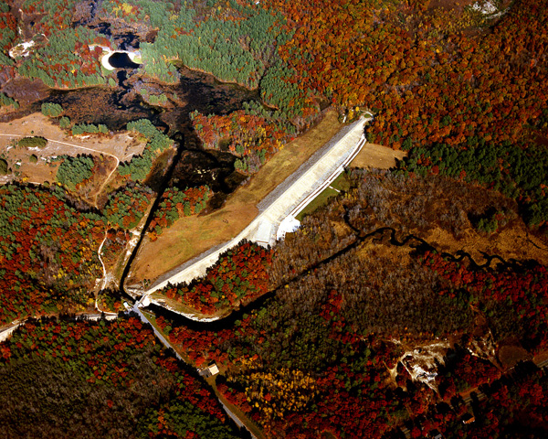
This tragedy prompted state governments to work with the U.S. Army Corps of Engineers to hasten the building of several flood control dams that had already been authorized by the Congress. West Hill Dam is part of the resulting network of flood control structures. Construction at West Hill Dam began in June 1959 and completed in June 1961, requiring the relocation of several town roads and utilities. The cost of construction was $2.3 million. The project consists of an earthfill dam with stone slope protection 2,400-feet long and 48-feet high; four earthfill dikes with stone slope protection totaling 1,910 feet in length with a maximum elevation of 14 feet; three gated conduits, each measuring five-feet high, three feet wide, and 39-feet long; and a chute spillway cut in rock with a concrete weir 50-feet long. The weir’s crest elevation is 18 feet lower than the top of the dam. The project has prevented $96.6 million in flood damages since it was built (as of September 2011).
The dam is designed to hold back flood waters during heavy rains, until rivers begin to recede and the stored water can be safely released. West Hill protects Uxbridge, Mass., and Woonsocket and Providence, R.I., and other communities along the Blackstone River in both states.
There is no lake at West Hill Dam. The flood storage area of the project covers 1,025 acres and extends about 4.7 miles upstream into Northbridge and Upton. This area is normally empty and is utilized only to store floodwaters. The project and all associated lands cover 1,401 acres. West Hill Dam can store up to 4.04 billion gallons of water for flood control purposes. This is equivalent to 8.3 inches of water covering its drainage area of 27.9 square miles.
The Reservoir Control Center (RCC) in Concord, Mass., is the nerve center for managing all the flood control dams in New England. Hydrologists and engineers use satellite communications and computer technology to constantly monitor river levels and weather conditions. They decide when and where to close the floodgates of the dams and store flood water in the reservoir valleys. They release the water as soon as possible, to be ready for the next storm that may threaten downstream communities.
For more information, current events, upcoming programs, or shelter reservations, call (508) 278-2511 or visit the website at: http://www.nae.usace.army.mil/Missions/Recreation/WestHillDam.aspx.
- Updated: May 4, 2021