The dam at Littleville Lake is located on the Middle Branch of the Westfield River in Huntington and Chester. From Westfield, visitors can reach the dam by taking Route 20 west to Huntington, then Route 112 north.
In conjunction with Knightville Dam, Littleville Lake provides flood protection to Huntington, Westfield, West Springfield, and other communities on the Westfield River. Littleville Lake also helps to reduce damages along the main stem of the Connecticut River. Littleville Lake is a multipurpose reservoir, serving as a backup water supply area for Springfield in addition to its flood control function.
Construction of the dam began in June 1962 and was completed in October 1965, costing $6.8 million. Relocation included about five miles of town roads, seven miles of utilities, and a 350-grave cemetery. The project has prevented $148.5 million in flood damages since it was built (as of September 2011).
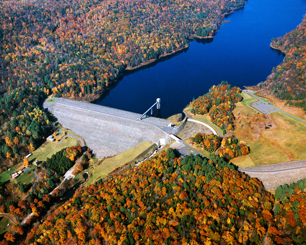
Littleville Lake consists of an earthfill dam with stone slope protection 1,360-feet long and 164-feet high; a 935-foot-long earthfill dike with a maximum elevation of 46 feet; a gated horseshoe conduit, eight feet in diameter, with a length of 374 feet; and a chute spillway cut in rock with a concrete weir 400-feet long. The weir’s crest elevation is 20 feet lower than the top of the dam. The dam also has a 790-foot-long, four-foot diameter gated concrete conduit used specifically for water supply purposes.
Littleville Lake contains a 275-acre water supply pool that has a maximum depth of 90 feet. The flood storage area of the project totals 510 acres and extends 3.7 miles upstream, principally through the town of Chester. The lake and all associated lands cover 1,579 acres. Littleville Lake can store up to 7.49 billion gallons of water for flood control purposes. This is equivalent to 8.3 inches of water covering its drainage area of 52.3 square miles.
In the April of 1987, the combination of melting snow and heavy rains caused the flood waters to rise 53 feet behind the dam, filling Littleville Lake to 90% of its capacity. Littleville Dam prevented an estimated $11 million in flood damage to downstream communities during this one storm event.
The Reservoir Control Center (RCC) is the "nerve center" for the New England flood damage reduction dams such as Littleville Lake. Using radio and satellite communications, the team constantly monitors river levels and weather conditions that influence flood risk management decisions.
Corps personnel, in conjunction with RCC regulate the amount of water released downstream by raising or lowering two gates located in the gatehouse at the dam. In a time of high water, the gates are lowered in order to hold back the water, only to be released when downstream river conditions begin to recede.
For details call (413) 667-3656 or visit http://www.nae.usace.army.mil/Missions/Recreation/LittlevilleLake.aspx.
- Updated: May 5, 2021