Hodges Village Dam in Oxford lies across the French River, about ten miles south of Worcester. From Worcester, visitors can reach the dam by taking U.S. Route 395 south to exit 413, one half mile on Sutton Street, one half mile on Charlton Street, right on Howarth Road.
This system controls flooding from Oxford, Mass., to Long Island Sound. In conjunction with Buffumville Lake, Hodges Village Dam reduces flood levels on the French River in Oxford, Webster, and Dudley, Mass., and Thompson, Conn. Hodges Village Dam also helps to reduce flooding extending downstream from Putnam, Conn., on the Quinebaug River to Norwich, Conn., on the Thames River.
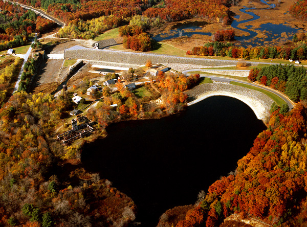
Construction of Hodges Village Dam was initiated in March 1958 and completed in December 1959, costing $4.5 million. Portions of both Route 12 and a railroad track were relocated. The project consists of an earthfill dam with stone slope protection 2,140-feet long and 55-feet high; four earthfill dikes with stone slope protection totaling 2,600 feet in length with a maximum elevation of 16 feet; two gated rectangular concrete conduits, each six-feet high, five-feet wide, and 206- feet long; and a chute spillway cut in rock, with a 125-foot-long concrete weir. The weir’s crest elevation is 19 feet lower than the top of the dam. The project has prevented $153.5 million in flood damages since it was built (as of September 2011).
There is no lake at Hodges Village Dam. The flood storage area of the project, which is normally empty and is only utilized to store floodwaters, covers 740 acres and extends upstream about three miles. The entire project, including all associated lands, covers 1,137 acres. Hodges Village Dam can store up to 4.17 billion gallons of water for flood control purposes. This is equivalent to eight inches of water covering its drainage area of 31.1 square miles.
The Reservoir Control Center (RCC) is the "nerve center" for the New England flood control dams such as Hodges Village Dam. Using radio and satellite communications, the team constantly monitors river levels and weather conditions that influence flood control decisions. The Reservoir Control Center provides information about river flows, dam operations, snow depths, recreational water releases, and more.
For more information, or for recreation opportunities call (508) 248-5697 or visit the website at: http://www.nae.usace.army.mil/Missions/Recreation/HodgesVillageDam.aspx.
- Updated: May 4, 2021