 Barre Falls Dam is located on the Ware River, about 0.3 mile below the junction of the river’s east and west branches and 13 miles northwest of Worcester, in the towns of Hubbardston, Barre, Rutland and Oakham, Massachusetts. From Gardner, Barre Falls Dam can be reached traveling south on Route 68 to Route 62 west.
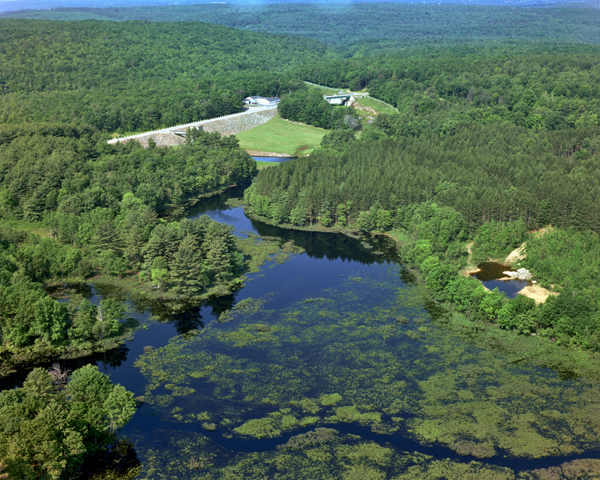
The dam substantially reduces flooding along the Ware, Chicopee, and Connecticut rivers. The project was authorized by Congress in 1941 to reduce flood damage from storms like those that devastated New England in 1936 and 1938. Construction of the project began in May 1956 and was completed in July 1958 at a cost of $2 million. A portion of Route 62 was relocated to accommodate the project. The project has prevented $53.2 million in flood damages since it was built (as of September 2011).
The project consists of an earthfill dam with stone slope protection 885 feet long and 69 feet high; three dikes totaling 3,215 feet in length with a maximum elevation of 48 feet; a 250-foot-long gated horseshoe conduit with a diameter of nine feet eight inches; and a chute spillway cut in rock with a 60 foot-long concrete weir. The weir’s crest elevation is 23 feet lower than the top of the dam.
There is no lake at Barre Falls Dam. The flood storage area of the project, which is normally empty and is utilized to store floodwaters, covers 1,400 acres in the towns of Barre, Hubbardston, Rutland, and Oakham. The entire project, including all associated lands, covers 2,407 acres. Barre Falls Dam can store up to 7.82 billion gallons of water for flood control purposes. This is equivalent to 8.2 inches of water covering its drainage area of 55 square miles.
The Barre Falls reservoir is located within the Upper Ware River Watershed. The Massachusetts Department of Conservation and Recreation (MDCR) manages and preserves the land for water quality protection. The Massachusetts Water Resources Authority (MWRA) manages the water resources, which is the public water supply for the metropolitan Boston area. The Corps assists the MWRA by coordinating flows to maximize diversion rates, and the MWRA assists the Corps when requested to divert excess flows to help with flood control. Therefore, camping, swimming and wading are not permitted.
About 490 acres of the reservoir area are leased to the Massachusetts Division of Fisheries and Wildlife for wildlife management. Brook, brown, and rainbow trout are stocked by the state in the Ware River. The state also stocks pheasant for in-season hunting. The area is open for hunting in accordance with state laws and regulations.
The Reservoir Control Center (RCC) directs the water regulation activities for 31 flood risk management projects including Barre Falls Dam. RCC and Barre Falls Dam team members coordinate the use of radio and satellite communications and computer programs to continuously monitor river levels and weather conditions that influence water control decisions. Using these tools and first-hand observations, the Corps of Engineers can rapidly respond to the unpredictable New England weather.
For more information, or for recreation opportunities, call (978) 928-4712 or visit the website at: http://www.nae.usace.army.mil/Missions/Recreation/BarreFallsDam.aspx.
- Updated: May 5, 2021