Weymouth Fore River and Town River were considered separate Corps’ projects until 1965, when they were combined into one project. Described below is the work completed by the Corps in the respective rivers when they were separate projects and after the projects were merged.
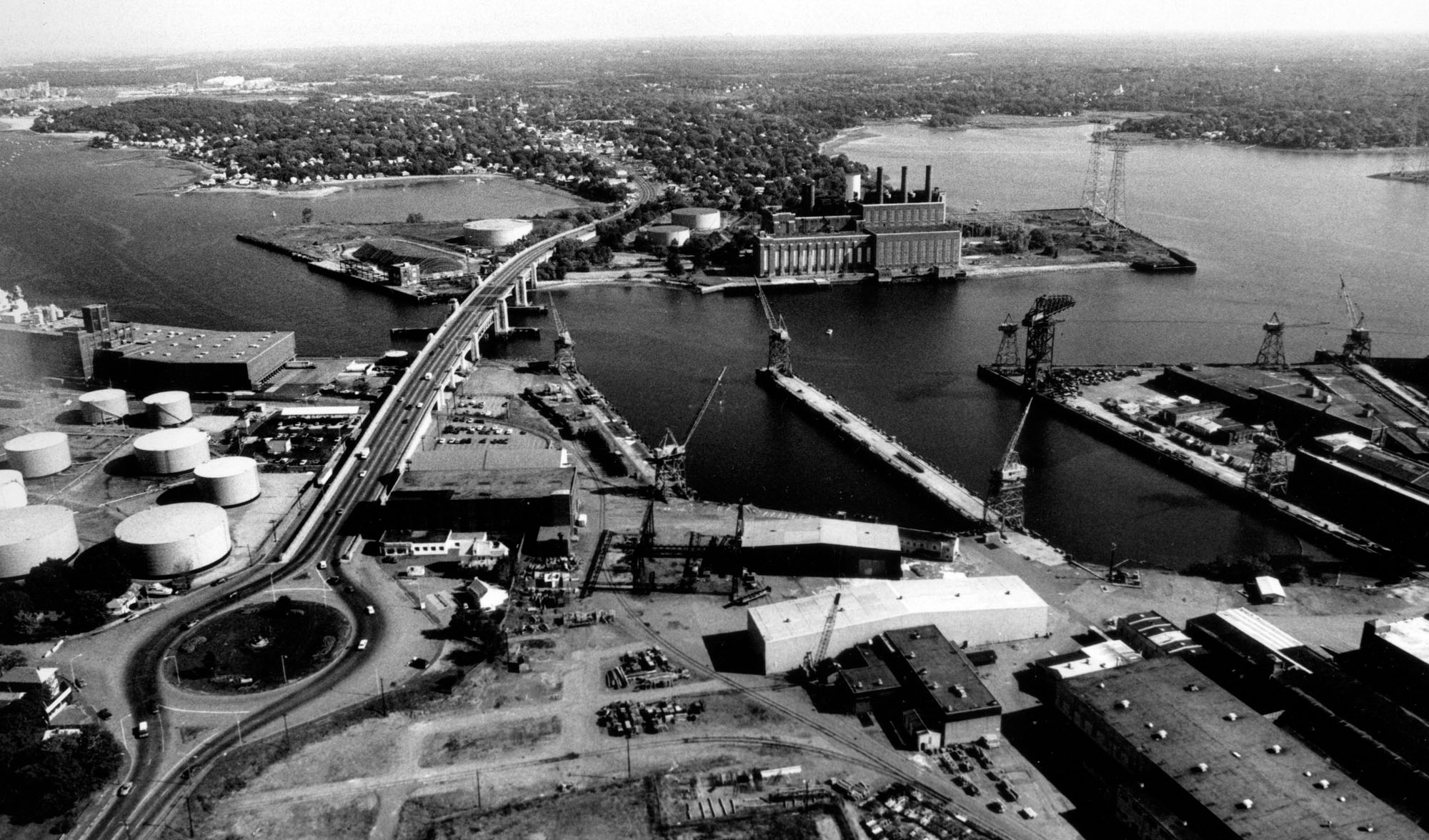
WEYMOUTH FORE RIVER (before 1965) Weymouth Fore River stretches for five miles from the mouth of the Monatiquot River in Braintree to Hingham Bay, about nine miles south of Boston. Most of the river’s upper end, from Smelt Brook at the Route 53 Bridge to a point about 0.5 mile upstream of the Fore River Bridge (Route 3A), lies along the Braintree-Weymouth line. The middle and outer sections of the inlet lie along the Quincy-Weymouth line.
Initial work on Weymouth Fore River, completed in 1927, consisted of a channel 24 feet deep extending about three miles from Hingham Bay to the Fore River Bridge. In 1960, the Corps completed additional work on the river. This work included:
- A channel through West Gut, which connects Hingham Bay (to the east) and Quincy Bay in Quincy (to the west). The channel is 27 feet deep and 300 feet wide.
- A 30-foot-deep channel that begins at Nantasket Roads (a naturally deep anchorage northwest of Hull), passes through the area between Nantasket Gut in Hull and Peddocks Island, and ends at the Fore River Bridge. The channel’s original width was generally 500 feet wide from Nantasket Roads through Nantasket Gut, then generally 300 feet wide across Hingham Bay to the Fore River Bridge. The channel extends about 2,700 feet upstream of the bridge to form a turning basin 470 feet to 650 feet wide at the site of the former General Dynamics shipyard.
TOWN RIVER (before 1965) Town River, which lies entirely within Quincy city limits, is a tidal river about two miles long that empties into Weymouth Fore River between Quincy Point and Germantown Point. Initial work on Town River, completed in 1906, consisted of a channel four feet deep extending westward from the Weymouth Fore River.
In 1958, the Corps completed additional work on the river. This work included a channel 27 feet deep and 250 feet wide extending about 1.3 miles from deep water in Weymouth Fore River to a point opposite the Quincy Oil Company terminal. Included as part of the channel’s upper end was a 24-foot-deep turning basin with a general width of 400 feet. Also included was a 15-foot-deep channel 100 feet wide extending from the head of the 27-foot-deep channel upstream about 1,300 feet to a point just below the Quincy Electric Light and Power Company.
WEYMOUTH FORE RIVER AND TOWN RIVER (after 1965) In 1965 the two projects were combined and modified to facilitate navigation. These improvements included:
- Deepening to 35 feet the existing 30-foot-deep channel that extends from deep water in Nantasket Roads, past the Fore River Bridge, to the turning basin at the site of the former General Dynamics shipyard.
- Widening a portion of the aforementioned channel. The width of the channel section from deep water in Nantasket Roads through Nantasket Gut remained at 500 feet. However, the channel width across Hingham Bay to the mouth of Weymouth Fore River increased from 300 to 400 feet. The width of the channel from the mouth of Weymouth Fore River to the Fore River Bridge remained at 300 feet, and the channel width from the bridge to the turning basin remained generally at 400 feet wide.
- Constructing a six-foot-deep channel on Weymouth Fore River extending from the head of the 35-foot channel along the former General Dynamics shipyard to the public landing in Braintree (Watson Park). The 8,000-foot-long channel, which meets the needs of recreational navigation, is initially 100 feet wide, then narrows to 80 feet, then finally to 60 feet. This channel was completed in July 1983 as a small project under Section 107 of the Continuing Authorities Program.
- Deepening to 35 feet the existing 27-foot-deep Town River channel that extends from deep water in Weymouth Fore River to the turning basin opposite the Quincy Oil Company terminal. The channel was also widened to 300 feet, increasing to 400-500 feet at the bends.
- Enlarging and deepening to 35 feet the existing 24-foot-deep turning basin in Town River.
- Dredging a turning basin 35 feet deep in King Cove, opposite the confluence of the Weymouth Fore and Town Rivers.
- Adding about six acres in area to an existing state-built eightfoot-deep anchorage in Town River. This additional acreage compensates for that part of the anchorage usurped when the Town River channel was widened to 300 feet.