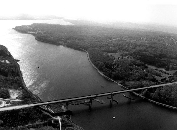
 The Thames River is formed by the confluence of the Shetucket and Yantic rivers in Norwich and flows south for 12 miles to New London Harbor. It serves (in upstream order) commercial and recreational waterfronts in the communities of New London, Groton, Waterford, Ledyard, Montville, and Norwich.
The earliest work on the Thames River was completed by the Corps in 1836 and modified in 1879. This work included dredging and deepening the river channel and constructing several piers. The most recent work on the river, completed in 1942, provides for:
-
A 25-foot-deep channel, about 10.5 miles long, extending from the area east of Mamacoke Cove in New London (almost two miles north of the New London Highway Bridge) to Norwich, at the mouth of the Shetucket River. The channel is 250 feet wide from Mamacoke Cove to Bartlett Crossover (about four miles upstream of the New London Highway Bridge), then 200 feet wide from Bartlett Crossover to Norwich. (In 1980, the Department of the Navy deepened a portion of this channel to 36 feet. The new depth begins at the US Route 95 Bridge and extends to the upstream end of the U.S. Naval Submarine Base in Groton. The Corps is responsible for maintaining this part of the channel to a depth of 36 feet and a width of 250 feet if required by military and commercial vessel traffic).
-
Widening the channel opposite the U.S. Naval Submarine Base from 250 to 350 feet, with the widened area having a depth of 20 feet. This work was completed by the Department of the Navy in 1940.
-
Five training dikes in the upper three miles of the river that help keep sediment from settling at the bottom of the channel. These dikes are: Norwich Dike (1,050 feet long); Rolling Mill Dike (3,480 feet long); Trading Cove Dike (2,370 feet long); and Mohegan Dike (2,990 feet long).
-
The removal of obstructions at the mouth of the Shetucket River.