The dam at Wrightsville Reservoir in Montpelier is located on the North Branch of the Winooski River, about 40 miles southeast of Burlington. From Montpelier, the dam is three miles north on Route 12.
The project provides flood protection primarily to Montpelier. In conjunction with East Barre Dam and Waterbury Reservoir, the project also reduces flood damage in other downstream communities, including Middlesex and Waterbury on the Winooski River.
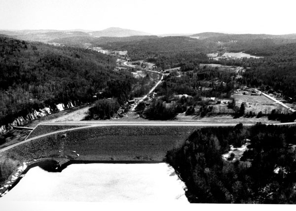
Construction of the project began in August 1933 and was completed in October 1935. The project consists of an earthfill dam with stone slope protection 1,525 feet long and 115 feet high; a 645-foot-long concrete rectangular conduit divided into three barrels, with one barrel plugged, one barrel leading to the Wrightsville Hydroelectric Power Plant (see below), and the third measuring 5.25 feet wide and 5.25 feet high; and a spillway cut in rock with a 155-foot-long concrete ogee weir. The weir’s crest elevation is 30 feet lower than the top of the dam. Wrightsville Reservoir was one of four flood damage reduction projects constructed in Vermont by the Civilian Conservation Corps in the 1930s. Construction was overseen by the Corps’ North Atlantic Division. Because of accounting procedures, the construction costs of Wrightsville Reservoir were not calculated separately, but instead lumped together with the construction costs of East Barre Dam, Waterbury Reservoir, and the Winooski River Local Protection Project. The construction costs of these four projects totaled $13.7 million. Following completion, Wrightsville Reservoir was turned over to the State of Vermont for operation and maintenance.
The present day configuration of the dam is the result of a major modification that allows a greater amount of water to pass through the spillway, increasing the dam’s structural integrity. Started in October 1956, the modification included raising the dam 20 feet and lengthening it 275 feet, and widening the spillway discharge channel. A 1,920-foot-long section of a town road was relocated across the top of the dam. The work was completed in September 1958 at a cost of $1.35 million.
Prior to 1985, Wrightsville Reservoir had a permanent recreational pool of 90 acres with a maximum depth of about 10 feet. However, since the construction of the Wrightsville Hydroelectric Power Project in 1985, the permanent recreational pool is now kept at 190 acres with a maximum depth of 25 feet. The flood storage area of the project, which is normally empty and utilized only to store floodwaters, totals 570 acres and extends one mile upstream through Middlesex. The project and all associated lands cover 836 acres. Wrightsville Reservoir can store up to 6.6 billion gallons of water for flood control purposes. This is equivalent to 5.6 inches of water covering its drainage area of 68.1 square miles.
Wrightsville Reservoir was originally constructed without any recreational facilities. In November 1964, the Corps began work on providing the lake with three recreational areas and completed the project in June 1967 at a cost of $204,600 (the state provided fireplaces, picnic tables, drinking water, and sanitary facilities). In November 1967, the Corps turned over these recreational areas to the Vermont Department of Environmental Conservation. One area, the Shady Rill Recreation Area, is approximately 1.25 miles north of the dam (the .25-mile-long access road to Shady Rill is directly off Route 12). The Shady Rill Recreation Area offers picnicking on 10 tables and five fireplaces, a picnic shelter, an open field for ball playing, horseshoe pits, and sanitary facilities. Martins Brook, also known as Shady Rill Brook, offers picnickers a streamside environment. The second recreation area is the Wrightsville Reservoir Boat Launch Area, located on Route 12, about .75 mile north of the dam. This area offers a boat ramp and sanitary facilities. Cross-country skiing and snowmobiling on unmarked trails, as well as ice fishing, can be enjoyed during the winter.
The third recreational area built by the Corps at Wrightsville Reservoir has since been closed. However, in 1985, the Washington Electric Cooperative constructed a recreational facility in conjunction with the Wrightsville Hydroelectric Power Project it was concurrently building at Wrightsville Reservoir. This area, the Wrightsville Beach Recreation Area, is located on Route 12, about 1.25 miles north of the dam (opposite the access road leading to the Shady Rill Recreation Area). The Wrightsville Beach Recreation Area offers picnicking on 36 tables, 11 fireplace grills, a picnic shelter, swimming on 350 feet of beach, hiking on a one-half-mile long marked trail, an open field for ball playing, a small playground area, cold showers, drinking water, and sanitary facilities. Also offered are horseshoe pits and a volleyball net, with both the horseshoes and volleyball available in the office. When the Wrightsville Beach Recreation Area was completed, the Washington Electric Cooperative turned it over to the Wrightsville Beach Recreation District for operation and maintenance. The Wrightsville Beach Recreation District is comprised of the communities of Middlesex, Worcester, Montpelier, and East Montpelier.
Boating is permitted throughout Wrightsville Reservoir, although speed is restricted in the Wrightsville Beach Recreation Area.
There is fishing throughout Wrightsville Reservoir. The state stocks brown trout, and the lake supports self-sustaining white suckers, yellow perch, brown bullhead, pickerel, golden shiners, and pumpkinseed. Smallmouth bass have been introduced to the reservoir. Reservoir lands offer in-season hunting for waterfowl and trapping for muskrat.
In February 1985, the Wrightsville Hydroelectric Power Project was completed on North Branch, approximately 200 feet downstream of the dam at Wrightsville Reservoir. The facility began to generate power in September 1985. The plant has the capacity to produce 1.2 kilowatts of power, which is used by the Washington Electric Cooperative.
- Updated: 11 June 2015