The Cape Cod Canal, the widest sea-level canal in the world, extends 17.4 miles across the narrow neck that joins Cape Cod to the mainland. It is in Bourne, about 50 miles south of Boston via Route 3.
The canal saves commercial and recreational vessels 65-150 miles (depending on trip origin and destination) from the route on the outer Cape, where shoals and treacherous currents have made navigation hazardous for centuries. The toll-free waterway is open for passage to all boating craft properly equipped and considered seaworthy. Two-way traffic is routinely maintained.
The Cape Cod Canal is the most expensive navigation project built by the Corps in New England, costing $33 million. However, the benefits of serving commercial and recreational interests by eliminating the dangerous outer cape route far outweigh the costs.
 History The canal has a rich and interesting history. Originally, no crossing existed between Cape Cod Canal and Buzzards Bay. As early as 1623 Myles Standish of Plymouth Colony explored the idea of a canal as he traversed the area to reach the Aptucxet Trading Post, established to encourage commerce among the colonists, Dutch merchants in New Amsterdam, and local Indian tribes, on the Cape’s southern shore. Surveys, studies, and investigations recommending the construction of a canal followed in steady procession for 250 years. During this time, hundreds of ships that went around the Cape were shipwrecked from sudden and severe coastal storms, taking lives and cargo to the bottom. In 1880, a charter was granted to the Cape Cod Canal Company to construct a canal across the narrow isthmus. Although the company brought in about 500 laborers armed with shovels and wheelbarrows, work soon stopped and the charter lapsed. Another charter was granted in 1883 to the Lockwood Manufacturing Company of East Boston. This firm constructed a large dredge and began work digging a canal. However, because the dredge could excavate and discharge only 4,000 cubic yards of material in 10 hours, it proved inefficient and the project soon came to an end. During the next 25 years several charters were granted and small attempts were made at digging, but all were quickly abandoned. Many saw the great potential of a canal across the cape, but almost no one was willing to risk their own money to build it.
In 1907 financier August Belmont, a New York investment banker who built that city’s first subway, purchased the charter to build a canal and secured financial backing. In June 1909, Belmont began work on the long-awaited waterway. Finally, in July 1914, the Cape Cod Canal became a reality and opened with great pomp and circumstance as a toll seaway.
It wasn’t long, however, before problems appeared. The canal’s dimensions at that time (25 feet deep and 100 feet wide) were considerably smaller than those of the canal today and allowed only one-way traffic, causing significant delays and inconveniences. Combined with strong tidal currents that caused numerous accidents, the canal developed a negative reputation among mariners, and tolls and shipping soon fell. The Cape Cod Canal had proven to be neither a commercial nor transportation success. In July 1918, a German U-boat sank four barges and damaged a tug boat three miles off Cape Cod during the First World War. Alarmed by the proximity of the U-boats to American waters, the U.S. Government assumed control over the canal to bolster its defenses.
On March 1, 1920, the federal government returned control of the canal to Belmont’s company, but the company didn’t accept it, saying the government’s control during World War I had ended the company’s rights to the canal. With all parties washing their hands of the money-losing waterway, it closed. However, Massachusetts Governor Calvin Coolidge appealed to the company to open the canal, which it did three days later. Not wishing long and tedious buy-and-sell negotiations with the federal government and faced with the uncertainty of legal expense, Belmont’s company promptly settled on a price and sold the canal to the government in July 1921 for $11.5 million. Because of congressional delays in appropriating monies and legal problems with land titles, the government did not acquire the title to the Cape Cod Canal until March 30, 1928.
The Canal Today Once the Corps acquired the Cape Cod Canal, it studied how the waterway could be improved. The experience gained by the government in operating the canal from 1929-1934 led to a reexamination of the channel’s dimensions. Construction of a canal measuring 32 feet deep and 480 feet wide began in 1935 and was completed in 1940. Existing draw-type highway bridges with navigation openings of only 140 feet were removed and new ones completed in 1935 to give more vertical height to passing ships. The transformation of the Cape Cod Canal from a narrow, little-used shipping lane to one of the nation’s safest and most efficient navigational waterways had begun.
Further improvements essential to the operation and maintenance of the canal quickly followed. The annual tonnage of shipping through the canal increased dramatically. Today there are several features that help make the canal safe for commercial and recreational interests. The Canal is 17.4 miles long and has a project depth of 32 feet below mean low water. These include:
- A 32-foot-deep approach channel extending from the vicinity of Cleveland Ledge in Buzzards Bay to the canal itself. The approach channel has a width of 700 feet from Cleveland Ledge to Wings Neck in Pocasset, then narrows to 500 feet wide from Wings Neck to the canal (Hog Island Channel).
- Two mooring basins. The West Mooring Basin, located at the head of Buzzards Bay on the east side of Hog Island Channel, is 3,300 feet long, 350 feet wide, and 32 feet deep. The East Mooring Basin in Sandwich, on the north side of the canal just inside the canal’s entrance from Cape Cod Bay, has dimensions of 2,500 feet in length, 350 feet in width, and 25 feet in depth.
- A 600-foot-long jetty and a 3,000-foot-long breakwater, both located at the entrance to the canal from Cape Cod Bay. The jetty is located on the southerly side, and the breakwater is situated on the entrance’s northerly side. These structures, originally built by Belmont, were included in the purchase of the Cape Cod Canal.
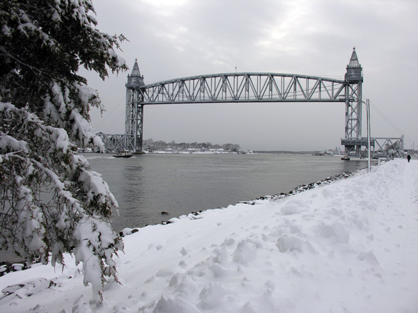
- A railroad bridge at Buzzards Bay and new highway bridges at Bourne and Sagamore. The three bridges, built simultaneously with Works Progress Administration funds, have vertical clearances of 135 feet at mean high water. The highway bridges have approach spans of 396 feet. The span of the railroad bridge is 544 feet and lifts vertically. It can be raised or lowered in about two and one-half minutes. A dike extending 10,700 feet southwesterly from Stony Point (Wareham Great Neck). A dike between Mashnee Island and Hog Island, in Bourne.
- A dike between Hog Island and Rocky Point, in Bourne.
- Two basins for small boats. The West Boat Basin, located west of the railroad bridge in Bourne immediately adjacent to the Cape Cod Canal Field Office, is 18 feet deep and one acre in area. The East Boat Basin, located on the south side of the canal in Sandwich opposite the East Mooring Basin, is 13 feet deep in the 2.3-acre outer basin and eight feet deep in the 4.3 acre inner basin.
- An improved, more energy efficient lighting system.
As part of the Cape Cod Canal project, the Corps also constructed some improvements to Onset Bay in Wareham. These improvements include:
- A 0.6-mile-long channel extending northwesterly from Hog Island Channel (at a point opposite the West Mooring Basin) to Onset Bay. The channel is 15 feet deep and 100 feet wide.
- A 15-foot-deep turning basin at the end of the Onset Bay channel, in the vicinity of the town wharf.
- Two eight-foot-deep anchorages on either side of the 15-foot channel in Onset Bay, in the vicinity of Wickets Island, that provide harbors of refuge for small vessels.
The Corps of Engineers operates and maintains the Cape Cod Canal from a field office in Bourne, west of the railroad bridge. Using state-of-the-art technology, experienced marine traffic control personnel regulate the movement of all vessels sailing the waterway 24 hours a day, seven days a week. Corps patrol boats maintain a constant vigil along the canal and assist vessels in distress, enforce speed limits, and remove floating debris. This professional approach to management earned the Cape Cod Canal the distinguished honor of "U.S. Army Corps of Engineers’ Project of the Year" in 1986.
Recreation The Cape Cod Canal is one of New England’s most popular recreational areas. Over four million visitors annually enjoy the canal and its adjacent lands for a variety of outdoor activities or simply to watch and identify the vessels that pass.
Some of the recreational opportunities offered by the canal are:
- A hiking trail that runs parallel to the canal for 1.5 miles. The trail, which runs through Bournedale Hills Woods, starts at the Herring Run Recreation Area (described below) and ends at Bourne Scenic Park. The trail has a one-half-mile section that loops back around to Herring Run.
- A bicycle trail that runs parallel to the canal. The bike trail is actually a service road used by the Corps to operate and maintain the canal. However, the only motorized vehicles that use the road are government vehicles. The trail is available for walking and other non-motorized recreational activity. The bike trail/service road is accessible from both Scusset Beach State Park and Bourne Scenic Park (described below).
- Interpretive Programs given by Cape Cod Canal rangers. These programs range from road walks along the canal that examine the canal’s history, to bike hikes that explore the canal’s environment, to spirited campfire programs where tales are told and marshmallows are toasted around a roaring campfire.
- Some of the best saltwater fishing in the country. Government land along both banks of the canal is available for anglers to catch waiting bass, flounder, cod, and mackerel.
- A boat ramp in the East Boat Basin. The boat ramp is located at the Sandwich Marina, which is leased by the Corps to the town of Sandwich.
There are seven recreational areas developed by the Corps throughout the length of the canal that allow the public to enjoy these and other activities. Each recreational area offers picnic tables (cooking with gas grills only), interpretive programs, access to the bicycle trail, canal fishing, drinking water, and parking and sanitary facilities. These recreational areas are:
- Herring Run in Bourne, on Route 6 (Scenic Highway). The most popular of the seven recreational areas, Herring Run has a visitor information center and a fish ladder that allow herring to swim from the canal to Great Herring Pond in Bourne and spawn. Herring Run also provides access to the hiking trail along the canal.
- Sagamore Bridge Area in Bourne on Canal Road, adjacent to the Sagamore Bridge Rotary.
- Tidal Flats Area in Bourne on Bell Road, near the railroad bridge. The bicycle trail is not accessible from this recreation area.
- Bourne Bridge Area in Bourne, beneath the Bourne Bridge.
- Midway Station in Bourne, along Sandwich Road (Route 6). Midway Station is a wooded area and is available by permit for group picnics. Canal fishing is not available. It is the only one of the seven recreational areas that does not lie alongside the canal.
- West Bulkhead Area in Sandwich on Freezer Road. This area is especially popular with sportsmen who enjoy fishing from the bulkhead alongside the canal.
- East Bulkhead Area in Sandwich on Coast Guard Road. Visitors can scan Cape Cod Bay for ships arriving at the east end of the canal.
Two large recreation areas adjacent to the canal provide visitors with many recreational opportunities. They are:
- Scusset Beach State Park in Sandwich, one mile east of the Sagamore Rotary on Route 6. This 380-acre facility offers 98 campsites, each with trailer electrical hookups, picnic tables, and fireplaces. Campers have access to hot showers, drinking water, sanitary facilities, and a dump station. Scusset Beach State Park also has a beach area with a bathhouse, sanitary facilities, and access to drinking water. Pier fishing along the canal is popular, and there are 75 acres available for in-season hunting of state stocked pheasant and native rabbit, deer, and fox. Interpretive programs are offered by the Corps to all park visitors. The park is leased by the Corps to the Massachusetts Department of Environmental Management.
- Bourne Scenic Park in Bourne on Route 6, about .25 mile from the Bourne Rotary. This 112-acre park offers 466 campsites (300 sites have trailer electrical hookups) with picnic tables. Campers have access to hot showers, drinking water, sanitary facilities, and a dump station. The park has a unique saltwater swimming pool that flushes with the tide. Pool users have access to sanitary facilities and drinking water. The Corps offers interpretive programs to visitors, and the park is available by permit for group picnics. Bourne Scenic Park is leased by the Corps to the Bourne Recreation Authority.