The Richford Local Protection Project is located on the Missisquoi River in Richford, at the confluence of the North Branch and Missisquoi River. The project is approximately one mile from the Canadian border.
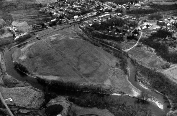
The project is designed to reduce damages caused by ice jam flooding in the vicinity of Big Island, which is situated at a sharp bend in the river west of the town center.
Ice jams along this section of the Missisquoi River did not occur prior to 1950 when the Sweat and Comings Dam existed (The Sweat and Comings Company, a furniture manufacturing firm, used the dam for power generation and log transportation). The 12-foot-high stone and timber dam, located approximately 250 feet upstream of the Main Street Bridge, showed significant deterioration in the 1940s and was removed in 1947. The first ice jam of record in Richford occurred in March 1950, causing, according to one source, "the greatest amount of property damage since the flood of 1927." Significant ice jam flooding also occurred in March 1955, April 1959, March 1960, and February 1961.
In response to a request from Vermont state officials for assistance, the Corps constructed a project in Richford between December 1961 and June 1964 at the cost of $221,000. The project was built by the Corps’ New York District and is maintained by Richford.
The project involved:
- Excavating a new channel through Big Island for 1,870 feet.
- Excavating 2,010 feet of an existing channel. The work begins in the main channel at a point about 860 feet downstream of the Main Street Bridge and extends into the existing stream south of Big Island. The channel is 40 feet wide.
- Constructing a 160-foot-long stone weir on the left bank of the main channel to prevent ice jams.
- Constructing a 350-foot-long stone dike on the right bank of the main channel.
- Removing two shoals at the mouth of North Branch and a small island about 300 feet long in the Missisquoi River.
The Corps of Engineers has conducted a study on providing additional ice jam flood protection to Richford.
The Missisquoi River rises from mountain streams on the eastern slope of Belvidere Mountain in Lowell and flows northerly through Westfield and Troy before entering the province of Quebec. The river flows through the province for about 12 miles before reentering the United States at Richford. The river then flows westerly through Berkshire, Enosburg, Sheldon, and Highgate, and enters Lake Champlain at Swanton. The river has a total length of 88 miles.