Life would be very different for area residents if not for North Springfield Dam and Lake. The dam was constructed and is operated by the U.S. Army Corps of Engineers, with a primary function of storing flood waters and seasonal runoff. It is located 8.5 miles upstream of the confluence of the Black and Connecticut rivers. North Springfield's dam is one of a series of flood control dams on tributaries of the Connecticut River.
The project provides flood protection to Springfield, and in conjunction with other Corps dams and reservoirs in the Connecticut River Basin, reduces flood damages to Connecticut River communities situated downstream.
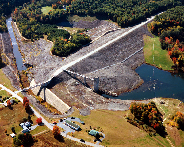
Construction of North Springfield Lake began in May 1958 and was completed in November 1960 at a cost of $6.8 million. The project consists of an earthfill dam with stone slope protection 2,940 feet long and 120 feet high; a 659-foot-long gated concrete horseshoe conduit with a diameter of 12 feet nine inches; and a spillway cut in rock with a 384-foot-long concrete ogee weir. The weir’s crest elevation is 24.5 feet lower than the top of the dam. Approximately three miles upstream of the dam is Stoughton Pond, situated on the North Branch of the Black River in Weathersfield. The pond is impounded by an embankment, which was the site of Route 22 before North Springfield Lake was built. The embankment is 900 feet long and was raised to a height of 75 feet by the Corps. Under this embankment the Corps constructed a 300-foot-long circular metal conduit with a diameter of eight feet, and an earthen spillway with a 200-foot-long broad-crested weir. The weir’s crest elevation is two feet lower than the top of the embankment. The work involved the construction of 3.8 miles of relocated roads and highway, and the relocation of a 150-grave cemetery. The project has prevented $134.8 million in flood damages since it was built (as of September 2011).
The construction of North Springfield dam consists of impervious earth and rock fill, with a side channel spillway located at the left abutment of the dam. The gatehouse is a concrete intake structure with three hydraulically controlled gates. Corps of Engineers staff control the gates which regulate the discharge of water through the dam. In addition to the dam at North Springfield Lake, a causeway was constructed that maintains a conservation pool inside the reservoir land. This body of water is known as Stoughton Pond. This structure has a 200-feet wide emergency spillway.
North Springfield Lake has a permanent pool of 100 acres with a depth of about 15 feet (Stoughton Pond has a permanent pool of about 65 acres with a maximum depth of about 20 feet). The flood storage area of the project totals 1,200 acres and extends 5.4 miles upstream through Weathersfield. The project and associated lands cover 1,755 acres. North Springfield Lake can store up to 16.7 billion gallons of water for flood control purposes. This is equivalent to 5.9 inches of water covering its drainage area of 158 square miles.
Although the dam is located in North Springfield, the Black River watershed is located throughout parts of Windsor and Rutland Counties. The Black River leading down to the dam has a drainage area of 204-square miles and a length of approximately 39 miles.
Nine major tributaries flow into the Black River and contribute to flooding and seasonal runoff. Historical flood data and precipitation records are analyzed to determine runoff characteristics of the Black River watershed. Peak seasonal runoff generally occurs during March and April which is associated with spring snowmelt. Normal spring snowmelt dose not contribute to significant flooding unless augmented by rainfall and warmer than normal temperatures. Corps of Engineers staff measure snow depths and water equivalency during the winter months at strategically chosen locations throughout the watershed. These measurements are used to model the spring runoff and help in evaluating possible flood events.
The Reservoir Control Center (RCC) is based out of the District Office in Concord, Mass., and oversee the flood control dams operated by the Corps of Engineers in New England. The engineers forecast flood events for the dams and associated rivers in New England. They then use the data to manipulate flows from each of the dams controlled by the Corps of Engineers to reduce or eliminate flooding damages. The RCC main page provides information about river flows, dam operations, snow depths, recreational water releases, and more for North Springfield Dam and the other Corps of Engineer dams in New England.
For more information, or for recreation opportunities, call (802) 886-2775 or visit the website at: http://www.nae.usace.army.mil/Missions/Recreation/NorthSpringfieldLake.aspx.
- Updated: May 4, 2021