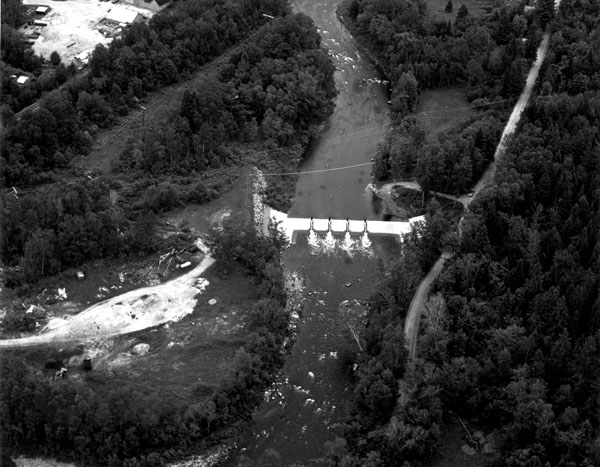
 The Israel River Local Protection Project in Lancaster is located on the Israel River, about 93 miles north of Concord. The project is approximately 0.5-mile upstream of the Main Street Bridge, and approximately 1,000 feet upstream of the covered bridge on Mechanic Street. The project was built at the site of a former wooden dam owned by the Twin State Gas and Electric Company. The Israel River flows into the Connecticut River about 1.5 miles downstream.
The project protects about 12 acres of commercial, industrial, and residential property in the center of Lancaster, including the Town Hall and police station, from flooding due to ice jams.
The Israel River is a steep, mountainous stream that becomes relatively flat as it flows through Lancaster. During the winter, large amounts of ice form upstream and float downstream to these flatter reaches, where it adheres to the bottom of the channel, particularly in the area of the Main Street Bridge in the center of town. These ice jams reduce the channel depths and limit the flow capacity of the river, causing the river to overflow its banks and flood public and private property. Since 1895, Lancaster has suffered more than 20 ice jam floods, the most serious occurring in March 1968. In March 1970, the Corps constructed an emergency rock dike across the Israel River at a point immediately upstream from the mouth of Otter Brook. The purpose of the dike was to hold floating ice upstream until a permanent structure could be constructed.
Construction of the present project began in May 1980 and was completed in September 1981 at a cost of $552,000. It was built under Section 205 of the Corps Continuing Authorities Program.
The project consists of a 160-foot-long, six-foot-high weir, made of earth and rock. The weir impounds ice and prevents it from flowing downstream and lodging against the Main Street Bridge. It is protected by layers of gabion, which are steel wire mesh baskets filled with stone, and is covered with 3-5 inches of concrete, which protects the gabion wires from cutting and other damage caused by ice and debris. A sheet of steel constructed along the center of the weir helps prevent water from flowing through the structure. Four openings in the weir, each four feet wide, provide passage for migratory fish: These openings contain slots for wooden stoplogs, which are inserted in late fall to prevent water from passing through the weir and insure a winter pool of about 56 acres behind the weir. The stoplogs are removed in the spring. There is a three-foot-deep stilling basin, lined with gabion, located immediately downstream of the weir. Water coming through the weir at a high velocity hits the stilling basin, which dispels the water’s energy and considerably slows its acceleration. Also, a 90-foot-long earthfill dike with stone slope protection was constructed in a low area adjacent to the weir’s right abutment. The dike, with a maximum height of 10 feet, confines the river when it is restricted by ice jamming at the weir.
Because of the project’s unique design, it is monitored by the Corps of Engineers to measure its effectiveness.