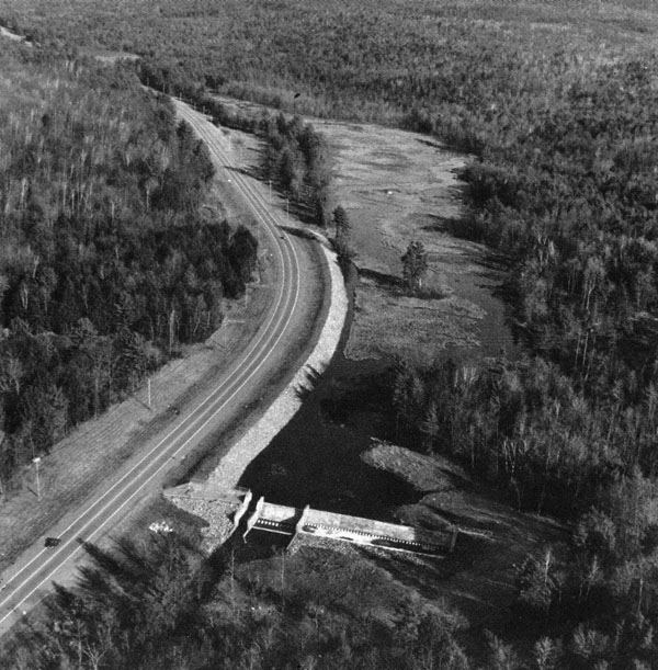
 The Beaver Brook Local Protection Project in Keene is located on Beaver Brook, a tributary of the Ashuelot River. It is about 42 miles west of Manchester.
The project reduces flood damages to residential, commercial, industrial, and public property along a 3.5-mile-long reach of Beaver Brook. This reach begins at Three-Mile Swamp and flows southerly for 2.5 miles before it enters Keene’s business district in the heart of the city. Beaver Brook then flows for about one mile through the business district before joining The Branch, which then flows into the Ashuelot River immediately outside of the downtown area.
Flooding along this 3.5-mile-long reach of Beaver Brook, particularly along the one mile of stream that passes through Keene’s business district, has been a recurring problem. The business district, from Water Street to Beaver Brook’s confluence with the Ashuelot River, is home to much of the city’s commerce and industry and some of Keene’s oldest and more densely populated neighborhoods. Since 1927, floodwaters from Beaver Brook have caused extensive damage to this area. Four of the more damaging floods on Beaver Brook in the last 40 years occurred in November 1950, October 1959, April 1960, and December 1973. The worst flooding on record, the hurricane of September 1938, caused damages totaling $1.1 million along the Ashuelot River and its tributaries. Along Beaver Brook, these losses were estimated at $218,000 and included damage to 347 homes, 15 commercial firms, and 10 industrial plants.
The Beaver Brook Local Protection Project was built between May-November 1986. Its construction dramatically demonstrates how a project can prevent damage during unexpected flooding. Only six months after it was completed at a cost of $2.7 million, the project prevented an estimated $1.6 million in flood damages during the heavy rains of April 1987.
The project was built under Section 205 of the Continuing Authorities Program and is operated and maintained by Keene. Work on the project consisted of replacing an existing 190-foot-long stone dam located at Three Mile Swamp with a 250-foot-long concrete dam and spillway. Three Mile Swamp is a natural flood storage wetland that is about six feet deep. The concrete dam and spillway is designed so that Three Mile Swamp will maintain its existing water level during non-flood periods and temporarily store floodwaters during periods of heavy rainfall and/or snowmelt. When filled to capacity, floodwaters behind the dam would cover 106 acres, including lowlands that lie adjacent to Three Mile Swamp. The dam does not eliminate flooding on Beaver Brook; instead, it temporarily stores floodwaters in the natural flood storage retention area of Three Mile Swamp and the adjacent lowlands, preventing these floodwaters from racing downstream and posing threats to lives and property, especially in Keene’s business district. Two earthfill dikes, totaling approximately 1,285 feet, were constructed to protect Route 10, situated adjacent to Three Mile Swamp, from flooding when the dam is storing floodwaters in the wetland. Dike A begins at the dam and runs parallel to Route 10. It is approximately 1,100 feet long, has a maximum height of 12 feet, and has stone slope protection. Dike B, which runs perpendicular to Route 10, is about 185 feet long and has a maximum height of eight feet. Slope protection in the section of Beaver Brook between Water and Marlboro streets consists of precast concrete paving blocks (gridblock), and was built on the lower four feet of each bank. Approximately 1,480 feet of slope protection was built on the left bank, and approximately 1,585 feet was constructed on the right bank. An 80-foot-long retaining wall was constructed on the right bank of Beaver Brook, in the section between Water and Marlboro streets. The wall consists of precast concrete blocks and has a maximum height of nine feet.
Important to the project are city-built retaining walls, situated on both banks in the section of channel between Water and Marlboro streets. These walls, constructed in previous years to help control Beaver Brook flooding, act in conjunction with the Corps-built works to provide flood protection to Keene. On the left bank, the retaining walls consist of approximately 120 feet of granite block and about 150 feet of gabion; on the right bank, the retaining wall consists of approximately 85 feet of gabion.