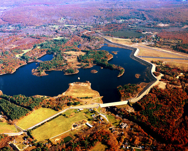
Mansfield Hollow Dam lies on the confluence of the Natchaug, Fenton and Mt. Hope Rivers, in Mansfield, Conn. The dam is part of a network of six flood control dams in the Thames River Basin constructed and maintained by the U.S. Army Corps of Engineers. This network helps to reduce flooding in communities within the Thames River Basin by regulating water levels on upstream tributaries in Connecticut and Massachusetts. The project provides substantial flood protection for the Shetucket River communities of Norwich, South Windham, Baltic, Occum, Taftville, and Willimantic. The lake lies within the boundaries of Mansfield and Windham, 25 miles east of Hartford. From Hartford, Mansfield Hollow Lake can be reached by taking Interstate 84 to Route 195 south.
Construction of the dam began in 1949 and was completed in May 1952. The cost of the project was $6.5 million. The project has prevented $108.4 million in flood damages since it was built (as of September 2011). The dam consists of earthfill with stone slope protection. It has a length of 14,050 feet and a height of 68 feet. The project also consists of six earthfill dikes with stone slope protection that total 2,656 feet in length and have a maximum height of 53 feet. A concrete spillway spans the main channel of the Natchaug River with a concrete weir 690 feet long. The weir’s elevation is 16 feet lower than the top of the dam. There are five gated rectangular conduits five-feet-six-inches wide and seven-feet high that vary in length up to 26 feet.
The lake at Mansfield Hollow stretches over 450 acres through Mansfield, Windham, and Chaplin. It has a maximum depth of 16.5 feet. The flood storage area of the project, which is normally empty and is only utilized to store floodwaters, totals 1,880 acres and extends about three miles up the Natchaug River, 2.3 miles up the Mount Hope River, and 3.2 miles up the Fenton River. The project and associated lands cover 2,581 acres. Mansfield Hollow Lake can store up to 8.3. billion gallons of water for flood control purposes. This is equivalent to 6.1 inches of water covering its drainage area of 159 square miles.
Total potential flood control storage at Mansfield Hollow Lake amounts to 16.1 billion gallons of flood water, at a maximum level of 257 feet above mean sea level. Water stored during potential flooding conditions is released after water levels downstream recede. The highest water level recorded at Mansfield Hollow Dam occurred in June of 1982 with a pool height of 52.6 feet where the normal pool height at that time of the year is kept at 18 feet. The pool at that time was approximately 66 percent full with another 9.4 feet to go before reaching spillway crest at 62 feet.
The Reservoir Control Center (RCC) in Concord, Mass., is the "nerve center" for New England flood control dams such as Mansfield Hollow. Using radio and satellite communications, the team constantly monitors river levels and weather conditions that influence flood control decisions. The RCC website is also loaded with information about New England river flows, dam operations, snow depths, recreational water releases, and more.
The U.S. Army Corps of Engineers regulates the flow of the Natchaug River, which exits the dam, by raising or lowering five, hydraulically operated sluice gates from within the dam.
The U.S. Army Corps of Engineers owns 2,472 acres, of which the State of Connecticut Department of Energy and Environmental Protection leases approximately 2,300 acres for recreation and natural resource management. The state of Connecticut manages Mansfield Hollow Lake, which is becoming an increasingly popular recreational attraction. On a graceful, pine-covered bluff overlooking the broad expanse of water, picnic tables and fireplaces for both families and large groups are available. Many acres of open field lie adjacent to the bluff and may be used for softball, touch football, volleyball, and other team sports and group activities. A 4.5-mile walking/cross-country skiing trail leads through former pastures and the stone foundation remnants of former homesteads. The persistent hiker may find evidence of habitation by the Nipmuck Tribe. Other park facilities include a boat ramp, drinking water, and parking and sanitary areas.
The lake provides excellent boating for sailboats, canoes, and small power boats. Fishermen can expect to find trout, bass, horned pout, and perch. In-season hunting of pheasant, quail, partridge, and small game animals is also permitted.
Guests at Mansfield Hollow Lake may wish to visit the village of Mansfield Hollow, located adjacent to the dam. This area has been designated a State Historic District and placed on the National Register of Historic Places in recognition of its unique characterization of a 19th century rural village.
The project annually attracts more than 574,900 visitors. Visitors spend an estimated $8.45 million within 30 miles of the lake. An estimated 237 jobs in the local community are supported by visitors to Mansfield Hollow Lake.
For more information call (860) 923-2982 or visit the website at: http://www.nae.usace.army.mil/Missions/Recreation/MansfieldHollowLake.aspx.
- Updated: May 4, 2021