The dam at Hancock Brook Lake is located on Hancock Brook in Plymouth, Conn., and 3.4 miles upstream of the confluence of the brook and the Naugatuck River. It is situated about 4.5 miles north of Waterbury. From Plymouth, it can be reached by taking Route 262 west to Graystone Road.
The dam is a part of a network of seven flood control reservoirs built by the Corps of Engineers in the Naugatuck River Basin. The project stores floodwaters to reduce flood damages on the Naugatuck River and the lower Housatonic River.
Construction began in July 1963 and was completed in September 1966. The total cost was $4.2 million. Project construction required the relocation of 1.3 miles of town roads and about two miles of railroad track. The project has prevented $52.5 million in flood damages since it was built (as of September 2011). The highest pool level recorded since the completion of Hancock Brook Dam was in June 1982. The water level rose to 23.4 feet at the dam, utilizing 58 percent of the storage capacity.
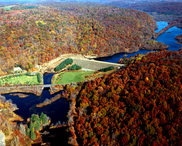
The project consists of an earthfill dam with stone slope protection 630-feet long and 57-feet high; a 2,300-foot-long earthfill dike with a maximum height of 35-feet along the relocated railroad track; an ungated 250-foot-long rectangular concrete conduit three feet wide and four feet six inches high; and a chute spillway cut in rock with a concrete weir 100 feet long. The weir’s crest elevation is 21 feet lower than the top of the dam. Maintenance of the dike is the responsibility of the railroad company.
Hancock Brook Lake contains a 40-acre conservation pool that has a maximum depth of six feet. The flood storage area of the project, which is normally empty and is utilized only to store floodwaters, totals 266 acres. The lake can store up to 1.27 billion gallons of water for flood control purposes. This is equivalent to 6.3 inches of water covering its drainage area of 12 square miles.
The Reservoir Control Center (RCC), in Concord, Mass., directs the water regulation activities for the New England flood control reservoirs such as Hancock Brook Lake. By way of radio and satellite communications, the team constantly monitors river levels and weather conditions that influence flood control decisions. The dam is regulated by a manually operated sluice gate on the upstream face of the weir to permit de-watering of the permanent pool. Operation and maintenance of the project site is by personnel at Hop Brook Lake.
The project offers lake fishing and one mile of stream fishing. The fish and game agencies of Connecticut and Massachusetts stock trout and salmon to complement the native bass, pickerel, perch, horned pout and bluegill. Reservoir waters are open to licensed fishermen under the regulations established by the Connecticut Department of Environmental Protection. A large boat launching ramp, a boat landing area, and sanitary and parking facilities are also available. Stocked pheasant and native small game may be hunted in season. Reservoir lands also offer the public opportunities for hiking, canoeing, and cross-country skiing.
More than 110,000 visitors annually enjoy the hiking, fishing and hunting opportunities available at Hancock Brook Lake’s 663 acres of land and water. Visitors spend an estimated $0.13 million within 30 miles of the lake. An estimated four jobs in the local community are supported by visitors to Hancock Brook Lake.
For more information call (203) 729-8840 or visit the website at: http://www.nae.usace.army.mil/Missions/Recreation/HancockBrookLake.aspx.
- Updated: May 4, 2021