 The dam at Hopkinton Lake, located on the Contoocook River in Hopkinton, and the dam at Everett Lake, located on the Piscataquog River in Weare, are connected by a two-mile long canal and in moderate to severe flooding are operated as a single flood risk management project. From Concord, the dam at Hopkinton Lake can be reached by traveling on U.S. Route 89 north to Route 9 (and 202) west to Route 127 north. From Manchester, the dam at Everett Lake can be reached by taking either Route 114 west through the Riverdale section of Goffstown, then right along River Road for about five miles, or the Everett Turnpike to Route 101, west to Route 114, west to Route 13 north.
The Hopkinton-Everett Lakes project provides flood protection to residential, commercial, and industrial property downstream on the Contoocook and Piscataquog rivers, which are tributaries of the Merrimack River. Hopkinton Lake protects the communities of Concord (including the Contoocook and Penacook sections), Boscawen, Canterbury, and Bow, while Everett Lake protects Manchester (including the Riverdale section) and Goffstown. Operating in conjunction with other Corps dams in the Merrimack River Basin, the project also helps protect major industrial centers along the Merrimack River, including Nashua and the Massachusetts communities of Lowell, Lawrence, and Haverhill.
In November 1927, New England rivers and streams, including the Merrimack River and its tributaries, went on a rampage. The resulting floods claimed several lives and caused serious flood damage. Less than nine years later, in March 1936, the worst flood in three centuries inundated the eastern and central United States. In New England, floodwaters claimed 24 lives, left 77,000 people homeless, and caused damage in New Hampshire and Massachusetts estimated at $36 million ($350 million in today’s dollars).
As a result of this devastation, New Hampshire and Massachusetts soon initiated a comprehensive plan to reduce the Merrimack River Basin’s disastrous flooding potential. In June 1938, Congress approved the construction of the Hopkinton-Everett dams as part of a coordinated system of flood risk management projects for the basin. When completed, the Hopkinton-Everett Dams would provide assurance that the horrors of the 1927 and 1936 floodwaters would not ravage communities in central and southern New Hampshire and northern Massachusetts. In September 1938, barely three months after Congress approved the project, the basin again suffered crippling flood losses when the most powerful hurricane ever to hit the region slammed into the northeast, overflowing riverbanks and causing widespread destruction. This storm served as a reminder that devastating floods could strike at any time and wreak havoc with lives and property.
Despite all good intentions, roadblocks soon appeared. One major problem revolved around reimbursement from Massachusetts to New Hampshire to compensate for the economic losses New Hampshire would incur by storing floodwaters behind the proposed dams.
It wasn't until 1957 that the state legislatures of New Hampshire and Massachusetts established the Merrimack River Valley Flood Control Commission, which cleared these roadblocks and smoothed the way for the project’s construction. An interstate compact was approved and the Corps initiated design studies. Construction of the dams began in November 1959 and was completed in December 1962 at a cost of $21.5 million. The work included relocating portions of Routes 9, 202, 114, and 127; utilities; an abandoned railroad; and four cemeteries. The two dams have prevented $217.1 million in flood damages since they were built (as of September 2011).
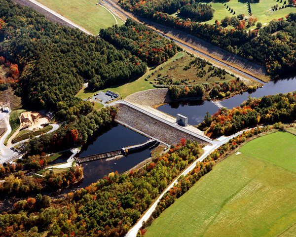
Construction of Hopkinton Dam was started in November 1959 and completed in January 1963. In addition to the protection of the Merrimack River Basin, Hopkinton Lake provides protection to downstream communities along the Contoocook River. The dam is an earth dam consisting of rolled earth fill with rock slope protection. It is approximately 790 feet long and 76 feet high.
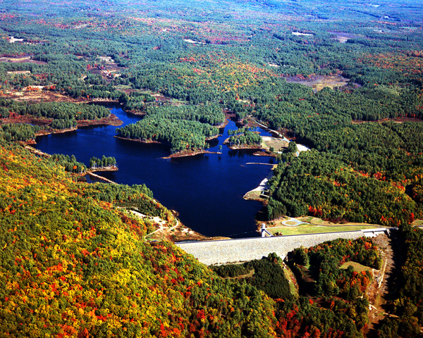
Construction of Everett Dam started in November 1959 and was completed in January 1962. As with Hopkinton Dam, it provides protection to the Merrimack River Basin and reduces flood levels in its downstream communities. Everett Dam is an earth dam consisting of rolled earth fill with rock slope protection. It is approximately 2,000 feet long with a maximum height of 115 feet.
Hopkinton Lake consists of an earthfill dam with stone slope protection 790 feet long and 76 feet high; three gated square concrete conduits, each measuring 11 feet high and 11 feet wide, with two conduits 124 feet long and the third 128 feet long; and a spillway excavated in rock. The spillway at Hopkinton Lake is unusual in that instead of being located adjacent to the dam as most spillways are, it is located about 1.8 miles east of the dam. The spillway, situated across Cressy Brook, has a concrete weir 300 feet long with a crest elevation 21 feet lower than the top of the dam. Everett Lake consists of an earthfill dam with stone slope protection 2,000 feet long and 115 feet high; a gated circular concrete conduit eight feet in diameter and 350 feet long; and a spillway excavated in rock with a concrete weir 175 feet long. The weir’s crest elevation is 17 feet lower than the top of the dam.
The project also has four earthfill dikes with stone slope protection (two at each dam) totaling 16,300 feet in length. At Hopkinton Lake, Dike One is located on Elm Brook, about .25 mile east of the dam, and is 5,220 feet long with a maximum height of 66 feet. Dike Two, located adjacent to the spillway across Cressy Brook about 1.8 miles east of the dam, has a length of 4,400 feet and a maximum height of 67 feet. At Everett Lake, Dike Three, located on Stark Brook about five miles north of the dam near the intersection of Routes 13 and Winslow Road, is 4,050 feet long with a maximum height of 50 feet. Dike Four, located on Route 77 about five miles north of the dam and .5 mile west of Dike Three, is 2,630 feet long with a maximum height of 30 feet.
The features that distinguish the dams at the Hopkinton-Everett Lakes project from other Corps-built dams in New England are two canals that act in conjunction to divert the floodwaters of the Contoocook River stored behind the dam at Hopkinton Lake to the flood storage area behind the dam at Everett Lake. During minor and moderate flooding, there is enough flood storage area behind the dam at Hopkinton Lake to store the floodwaters from the Contoocook River, and there is enough storage area behind the dam at Everett Lake to hold back floodwaters from the Piscataquog River. However, when major flooding occurs, there is not enough land behind the dam at Hopkinton Lake to hold the large volume of floodwaters from the Contoocook River. If not held back, these floodwaters would race downstream and threaten lives and property. There is, however, enough land behind the dam at Everett Lake on the Piscataquog River to hold not only potentially damaging floodwaters from the Piscataquog River, but also the excessive floodwaters from the Contoocook River that the dam at Hopkinton Lake cannot contain. The two canals act together to direct Contoocook River floodwaters from behind the dam at Hopkinton Lake to the flood storage area behind the dam at Everett Lake.
Canal I is located about .25 mile upstream of the dam at Hopkinton Lake and diverts water from the Contoocook River into Elm Brook Pool, situated behind the dam. The earthen canal is lined with rock and is approximately 4,000 feet long and 120 feet wide. Canal II is situated roughly halfway between the two dams; it is this canal that connects the flood storage area behind the dam at Hopkinton Lake with the flood storage area behind the dam at Everett Lake, allowing the two dams to function as a single unit. This canal has a total length of 10,400 feet (about two miles), of which 8,400 feet was cut in earth with a width of 160 feet. The upper 2,000 feet of the canal is Drew Lake, a natural body of water with a width roughly the same as the rest of the canal. During major flooding, floodwaters pass from the Contoocook River to Canal I to Elm Brook Pool, then pass into Canal II to Everett Lake.
Most flooding on the Contoocook River is either minor or moderate and does not require the transfer of excessive floodwaters through the canals. Since the project’s completion in December 1962, the diversion of Contoocook River floodwaters from behind the dam at Hopkinton Lake to the flood storage area behind the dam at Everett Lake has occurred only seven times, the last in April 1987 when the combined reservoir area of the two dams was filled to 95 percent of capacity, its highest level ever.
 The flood storage area behind Hopkinton Lake totals 3,700 acres and extends about 8.5 miles upstream through Henniker to the Contoocook Valley Paper Company. This acreage includes areas that are normally empty and areas that have permanent bodies of water. Some of the larger bodies of water behind the dam at Hopkinton Lake include the 220-acre permanent pool on the Contoocook River, which has a maximum depth of 14 feet; the 456-acre Elm Brook Pool; the 47-acre Drew Lake, which makes up the upper 2,000 feet of Canal II; and two lakes, approximately 87 and 35 acres respectively, located within the confines of Stumpfield Marsh. The flood storage area behind Everett Lake totals 2,900 acres and extends westerly up the Piscataquog River in Weare; northerly up Choate Brook, which lies mostly in Weare with a small portion lying in Dunbarton; and northerly up Stark Brook in Dunbarton. This acreage includes a 130-acre permanent pool with a maximum depth of 15 feet. Together, the flood storage areas behind both dams can hold 52.6 billion gallons of water, which would cover approximately 8,000 acres (12.5 square miles). This is equivalent to 6.8 inches of water covering its drainage area of 446 square miles. The lakes and all associated project lands cover 9,945 acres.
The Reservoir Control Center (RCC), located at the Corps' New England District Headquarters in Concord, MA, is the "nerve center" for all Corps-operated dams in New England. Using radio and satellite communications, RCC constantly monitors river levels and weather conditions and directs the operation of the dams during high flows.
For more information, or for recreation opportunities, call (603) 746-3601 or visit the website at: http://www.nae.usace.army.mil/Missions/Recreation/HopkintonEverettLake.aspx.
- Updated: May 4, 2021