 The Stamford Hurricane Protection Barrier is located in Stamford on Stamford Harbor, about 20 miles southwest of Bridgeport.
Stamford has been subject to heavy losses from storm tidal flooding since 1635. The September 1938 hurricane resulted in losses in the project area of almost $6 million. Hurricane Carol in 1954 caused $3.4 million in damage, of which $2.9 million could have been prevented if a hurricane barrier had existed at that time. The barrier today provides protection to about 600 acres, which includes principal manufacturing plants, a portion of the main commercial district, and residential sections.
Construction of this project started in May 1965 and ended in January 1969, costing $14.5 million. The city operates and maintains the Stamford Hurricane Protection Barrier, with the exception of the navigation gates, which are operated and maintained by the Corps. The project has prevented $38.4 million in flood and coastal storm damagessince it was built (as of September 2011).
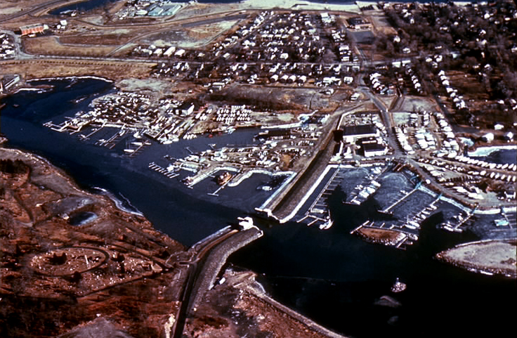
The project consists of three elements. The first, a barrier at the east branch of Stamford Harbor, is composed of a 2,850 foot-long earthfill dike with stone slope protection. It has an elevation of 17 feet. A 90-foot-wide opening is provided for navigation, and a pump station discharges interior drainage.
The second element is a barrier that provides protection at the west branch of the harbor. This barrier, which has an elevation of 17 feet, is composed of a 1,350-foot-long concrete wall; 2,950 feet of earthfill dike with stone slope protection and a pumping station. The third portion provides protection at Westcott Cove. This barrier is a 4,400-foot earthfill dike with stone slope protection having a maximum elevation of 19 feet. It also has two pumping stations.
The Reservoir Control Center (RCC), in Concord, Massachusetts directs the water regulation activities for the New England hurricane barriers such as Stamford. By way of radio and satellite communications, RCC constantly monitors river levels and weather conditions that influence flood control decisions. Park Rangers from Hop Brook Lake operate the Stamford Hurricane Barrier.
The barrier design was established through cooperation with the U.S. Weather Bureau and the Beach Erosion Board affiliated with the Texas Research Foundation of Texas A&M University. The basis for the design storm was the transformation of the September 1944 hurricane. This storm, when it was off the Cape Hatteras, N.C. coast, had the greatest energy of any known hurricane along the Atlantic coast. The 1944 storm was transposed so that it would be entirely over water between Cape Hatteras and the New England coast, resulting in a central pressure of 27.8 in. mercury near the mouth of Narragansett Bay, Buzzards Bay, and Long Island Sound. The transposed storm was moved northerly with a forward speed of about 40 knots along a track passing over New England 49 nautical miles west of Montauk Point, Long Island, creating sustained winds of 90 mph at the mouth of Long Island Sound and 55 mph from the southwest quadrant at the Stamford location in western Long Island Sound. Within Long Island Sound, at Stamford, a tide surge associated with this storm was computed to be 10.4 ft. This surge was added to the mean spring high water elevation of 4.4 Ft-NGVD, resulting in a 14.8 Ft-NGVD stillwater elevation. It was further determined that wave heights associated with this storm would be on the order of about 2.0 ft at time of peak surge resulting in a top of barrier elevation of 17.0 Ft-NGVD. A 14.8 Ft-NGVD design stillwater elevation is slightly greater than a 500-year tide level.