 Blackwater Dam in Webster is located on the Blackwater River, about 18 miles northwest of Concord. From Concord, it can be reached by taking U.S. Route 93 to U.S. Route 4 west, then south on Route 127.
Blackwater Dam significantly reduces flooding in the downstream communities on the Blackwater and Contoocook rivers, including Webster, Hopkinton, and Boscawen. In conjunction with the Franklin Falls Dam and the dams at Hopkinton and Everett Lakes, Blackwater Dam also reduces flooding in the major industrial, commercial, and residential centers on the Merrimack River, including Concord, Manchester, and Nashua, and the Massachusetts cities of Lowell, Lawrence, and Haverhill.
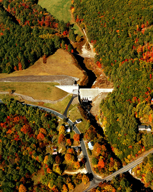
Construction of Blackwater Dam began in May 1940 and was completed in November 1941 at a cost of $1.3 million. The project consists of an earthfill dam with stone slope protection. The dam is 1,150 feet long with a maximum height of 75 feet; there are two earthfill dikes with stone slope protection totaling 1,650 feet. Little Hill Dike, located about three miles northwest of the dam, is 1,230 feet long and has a maximum height of 28 feet; and Dodge Dike, situated about .5 mile west of the dam, is 420 feet long with a maximum height of 20 feet. There are three gated rectangular conduits. Each conduit measures five feet three inches high, three feet six inches wide, and 65 feet long. A fourth ungated rectangular conduit was permanently plugged in 1951 to increase the effectiveness of the reservoir during flood periods. A spillway is cut in rock with a 240-foot-long concrete weir. The weir’s crest elevation is 18 feet lower than the top of the dam. The work included relocating about three miles of Route 127 and constructing smaller roads adjacent to the project. The project has prevented $77.4 million in flood damages since it was built (as of September 2011).
There is no lake at Blackwater Dam. The flood storage area of the project covers approximately 3,280 acres and extends upstream about seven miles through Salisbury, having a maximum width of one mile. The entire project, including all associated lands, covers 3,580 acres. Blackwater Dam can store up to 15 billion gallons of water for flood control purposes. This is equivalent to 6.7 inches of water covering its drainage area of 128 square miles.
The Reservoir Control Center (RCC) is the "nerve center" for the New England flood control dams such as Blackwater Dam. Using radio and satellite communications, the team constantly monitors river levels and weather conditions that influence flood control decisions. The Reservoir Control Center provides information about river flows, dam operations, snow depths, recreational water releases, and more.
For more information, or for recreation opportunities call (603) 648-6028 or visit the website at: http://www.nae.usace.army.mil/Missions/Recreation/BlackwaterDam.aspx.
- Updated: May 4, 2021