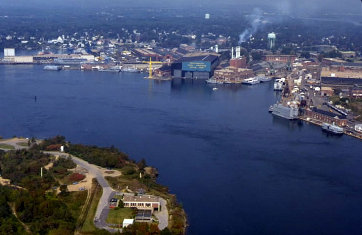
 Portsmouth Harbor is located on the Piscataqua River, which makes up a portion of the Maine-New Hampshire border. Portsmouth Harbor stretches across the communities of Kittery and Eliot, Maine, and Portsmouth, Newington, and New Castle, New Hampshire.
Located about 50 miles northeast of Boston, the harbor handles about 3.5 million tons of shipping a year for New Hampshire, eastern Vermont, and southern Maine. Items include petroleum products, iron and steel scrap, salt, limestone, and fish products. Portsmouth Harbor is used by submarines from the Portsmouth Naval Shipyard in Kittery. Known for its fast currents and sharp bends, the river is used extensively by a large lobstering fleet, local fishermen, excursion boats to the Isles of Shoals (nine miles offshore), and local and transient boats based at or visiting the nearly 20 boating facilities in the area.
Initial work in Portsmouth Harbor around the turn of the century consisted of:
- Constructing a 1,000-foot-long breakwater between Goat and New Castle islands. The breakwater now serves as a causeway for an access road to New Castle.
- Removing two ledge areas in the middle of the harbor. One area was opposite the western end of the Portsmouth Naval Shipyard, on the New Hampshire side of the channel. The second area was about 0.6 mile upstream, near the southwestern end of Badgers Island, on the Maine side of the channel.
The Corps has more recently completed three projects in the harbor constructed at separate times. The first project, approved by Congress and completed in 1966, consists of:
- A 6.2 mile long channel, 35 feet deep and generally 400-600 feet wide, extending northwesterly from deep water between New Castle and Seavey islands to a turning basin located about 1,700 feet past the Atlantic Terminal Sales dock in Newington. The bends were widened to 700 feet by removing ledge at Henderson Point, Gangway Rock, Badgers Island, the Maine New Hampshire Interstate Bridge, and Boiling Rock.
- Two 35 foot deep turning basins. The first turning basin is located above Boiling Rock and is 950 feet long. The second is situated at the end of the 6.2-mile-long channel in Newington and is 850 feet long.
In 1971, the Corps completed a second project, constructed under Section 107 of the Continuing Authorities Program (small projects). The work included:
- A 100-foot-wide main channel extending 0.4 mile from Little Harbor, through the Rye-New Castle drawbridge, then west to the mouth of Sagamore Creek. At this point, the channel forks into northern and western channels, described below.
- A 75-foot-wide northerly channel extending 0.7 mile between Leachs Island and Portsmouth to deep water south of Shapleigh Island.
- A 75-foot-wide westerly channel extending 0.9 mile up Sagamore Creek to the Route 1A Bridge in Rye.
- A six-foot-deep anchorage, three acres in area, was constructed at the upper end of the channel.
During the early 1990’s major improvements were completed in Portsmouth Harbor and the Piscataqua River to include widening the maneuvering area between the two vertical lift bridges from 600 feet up to 1,000 feet; widening by 100 feet the northern limit of the channel adjacent to Badgers Island; and widening by 150 feet the southern limit of the channel at Goat Island. The first phase of the work, which included the maneuvering area and the channel adjacent to Badgers Island, was complered in July 1990 at a cost of $13.5 million. The second phase, widening the channel at Goat Island, was completed in April 1992 at a cost of $2 million.