 The dam at Edward MacDowell Lake is located on Nubanusit Brook in Peterborough, about 14 miles east of Keene. From Nashua, the dam can be reached by taking U.S. Route 3 to Route 101A west (which turns into Route 101) through Peterborough. Continue on Route 101 for about two miles and follow signs to the dam.
Edward MacDowell Lake provides flood protection primarily to Peterborough. The project also provides flood protection to the downstream communities of Hancock, Bennington, Antrim, Deering, Hillsboro, and Henniker, all on the Contoocook River.
Construction of the dam began in March 1948 and was completed in March 1950 at a cost of $2 million. The project has prevented $20.8 million in flood damages since it was built (as of September 2011).
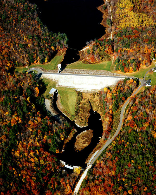
Edward MacDowell Lake consists of an earthfill dam with stone slope protection 1,100 feet long and 67 feet high; a gated concrete conduit, seven feet high, seven feet wide, and 275 feet long; and a chute spillway cut in rock. The spillway at Edward MacDowell Lake is unusual in that instead of being located adjacent to the dam as most spillways are, it is located 3.2 miles northeast of the dam, at Halfmoon Pond. The spillway has a concrete weir 100 feet long with a crest elevation 21 feet lower than the top of the dam. Discharges from the spillway flow from Halfmoon Pond into Ferguson Brook which, in turn, discharges into the Contoocook River.
There is a conservation pool at Edward MacDowell Lake covering an area of 165 acres and having a maximum depth of about seven feet. The flood storage area of the project totals 840 acres and covers parts of Hancock, Dublin, and Harrisville. The lake and all associated project lands cover 1,469 acres. Edward MacDowell Lake can store almost 4.2 billion gallons of water for flood control purposes. This is equivalent to 5.4 inches of water covering its drainage area of 44 square miles.
Hydrologists and engineers in the Reservoir Control Center (RCC) in Concord, Massachusetts, make flood control decisions for all of New England based on data collected from many sources, including USACE Park Rangers and the National Weather Service. The highly sophisticated "Automated Data Collection System", relays lake and river levels and weather conditions to the RCC computer system via the Geostationary Operational Environmental Satellite.
Water flow is regulated through the dam by opening and closing the steel gates in the gatehouse. MacDowell Dam has three gates each weighing 4 tons. The project staff lower the gates to hold back flood waters behind the dam when the Contoocook River and the Merrimack River reach high levels. When these two rivers return to normal flows, the gates are raised enough to allow the water behind the dam to return to its normal pool elevation.
For more information, or for recreation opportunities, call (603) 924-3431 or visit the website at: http://www.nae.usace.army.mil/Missions/Recreation/EdwardMacDowellLake.aspx.
- Updated: May 4, 2021