The dam at Surry Mountain Lake is located on the Ashuelot River in Surry, about five miles north of downtown Keene and 0.5 mile north of the Keene-Surry line, on Route 12A. In conjunction with Otter Brook Lake, Surry Mountain Lake provides flood protection to downstream communities on the Ashuelot River, including Keene, Swanzey, Winchester, and Hinsdale. Along with other Corps dams, Surry Mountain Lake also helps reduce flooding along the Connecticut River.
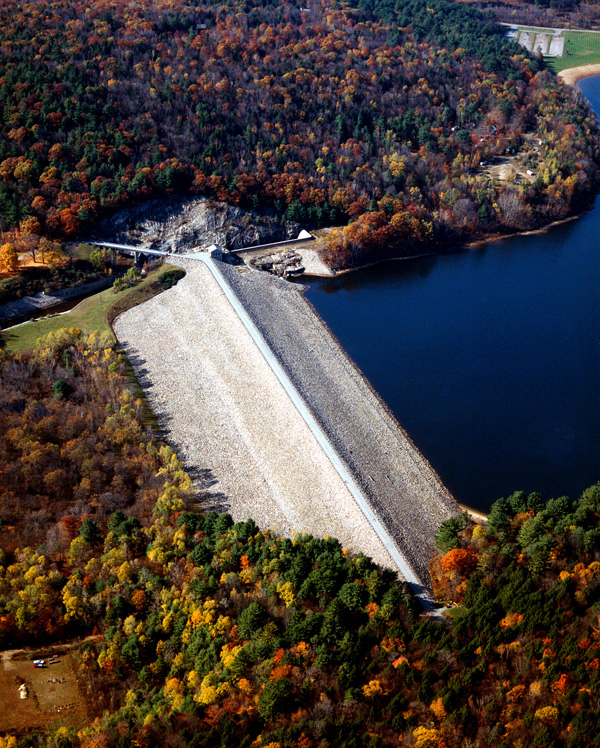
Construction on the project began in August 1939 and was completed in October 1941 at a cost of $2.8 million. The project consists of an earthfill dam with stone slope protection 1,800 feet long and 86 feet high; a concrete horseshoe conduit 10 feet in diameter and 383 feet long; and an L-shaped spillway excavated in rock with a concrete weir 338 feet long. The weir’s crest elevation is 18 feet lower than the top of the dam. The work included relocating a portion of Route 12A and a utility line.
In April 1987, two storms dropped over 4 inches of rain, and significant run-off occurred from snow melt, causing the first and only emergency spillway discharge to occur since the dam was built. Significant flooding did result in the Keene area, when the outflow rose to 2,250 cfs which greatly exceeded the channel capacity of 1,250 cfs. Although some flooding did result, it was estimated that Surry Mountain Dam prevented $7,956,000 in damages along the Ashuelot and Connecticut Rivers from that two storm event. The project has prevented $101.3 million in flood damages since it was built (as of September 2011).
Surry Mountain Lake contains a 260-acre recreation pool with a maximum depth of 15 feet that was established in 1962 at the request of the town. The flood storage area of the project totals 970 acres and extends about five miles upstream. The lake and all associated project lands cover 1,779 acres. Surry Mountain Lake can store almost 10.6 billion gallons of water for flood control purposes. This is equivalent to 5.9 inches of water covering its drainage area of 100 square miles.
The Reservoir Control Center (RCC), located in Concord, MA is the "nerve center" for the New England flood control dams such as Surry Mountain Lake. Using radio and satellite communications, RCC constantly monitors river levels and weather conditions that influence flood control decisions. By monitoring these conditions, RCC can coordinate the efforts of all the flood control facilities in New England
Park rangers, in conjunction with RCC, regulate the amount of water released downstream by raising or lowering two 4.5' x 10' gates located in the granite gatehouse at the dam. In a time of high water, the gates are lowered in order to hold back the water, only to be released when downstream river conditions begin to recede.
For more information, or for recreation opportunities, call (603) 352-2447 or (603) 352-4130 or visit the website at: http://www.nae.usace.army.mil/Missions/Recreation/SurryMountainLake.aspx.
- Updated: May 5, 2021