Black Rock Lake, on Branch Brook, is a part of a network of flood control dams and local protection projects built by the U.S. Army Corps of Engineers in the Naugatuck River Basin. The dam cost $8.2 million, and construction started in July 1967 and was completed in July 1971. It was built in response to the destructive flood of 1955. The project has prevented $217.1 million in flood damages since it was built (as of September 2011).
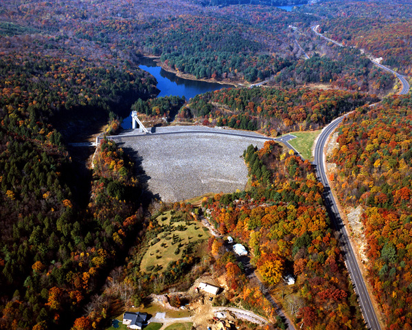
The dam is located adjacent to Black Rock State Park along the Thomaston-Watertown line. The reservoir is on Route 109, two miles west of Thomaston and within one mile of the intersection of Route 8 and U.S. Route 6. The project consists of an earthfill dam with stone slope protection 933-feet long and 154-feet high; a gated 704-foot-long circular concrete conduit four feet wide and five feet high; and a concrete chute spillway channel with a 140-foot-long weir. The weir’s crest elevation is 20 feet lower than the top of the dam. About 1.9 miles of Route 109 were relocated to accommodate the project.
The flood storage area of the project, which is normally empty and is utilized only to store floodwaters, encompasses over 190 acres in both Thomaston and Watertown. Together, the lake and associated lands total 319 acres. Black Rock Lake can store up to 2.83 billion gallons of water for flood control purposes. This is equivalent to eight inches of water covering its drainage area of 20.4 square miles.
The Reservoir Control Center (RCC) is the "nerve center" for the New England flood control dams such as Black Rock Lake. Using radio and satellite communications, the team constantly monitors river levels and weather conditions that influence flood control decisions.
Corps personnel, in conjunction with RCC regulate the amount of water released downstream by raising or lowering the two gates located in the control tower at the dam. In a time of high water, the gates are lowered in order to hold back the water, only to be released when downstream river conditions begin to recede.
The Reservoir Control Center provides information about river flows, dam operations, snow depths, recreational water releases, and more.
For more information, or for recreation opportunities, call (860) 283-4900 or (860) 283-5540 or visit the website at: http://www.nae.usace.army.mil/Missions/Recreation/BlackRockLake.aspx.
- Updated: 7 April 2016